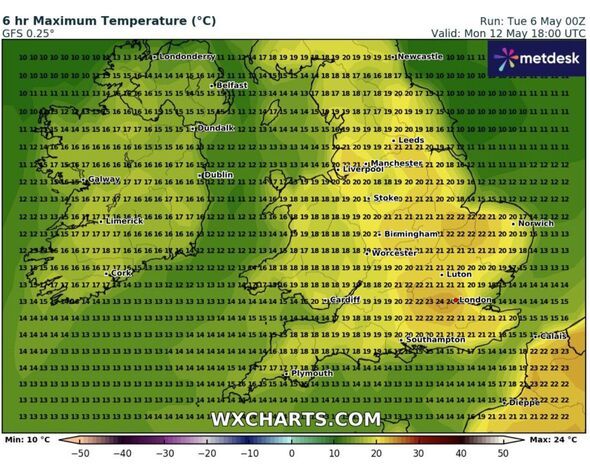
New have revealed the exact date that toasty 24C temperatures will hit Britain. In the latest forecast on WX Charts, graphs show that the mercury is set to rise to a scorching 24C in the south of England and parts of East Anglia on Monday, May 12, at 6pm.
Skegness, King's Lynn and parts of Hampshire and the south coast are set to see the highest temperatures on this date, according to the charts, which are compiled using Metdesk data.
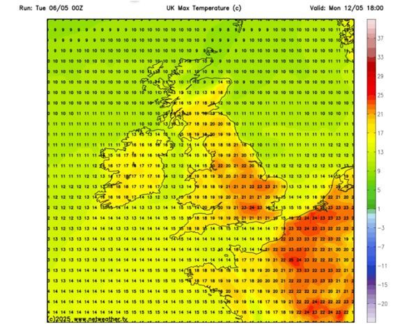
Elsewhere, it will be 21C in and around London, Essex, Kent, and Birmingham - while it will reach highs of 19C in Wales and Scotland. Down in Plymouth, temperatures are slightly at around 17C, while it wil be 19C in Newcastle, and just 10C in the Scottish Highlands. This appears to be backed up by Netweather, with maps turning dark red around the central London area indicating highs of 24C, with 23C temperatures in Lincolnshire, Norfolk, Hampshire and Buckinghamshire.
However, in its long-range forecast for the period between May 10 and May 19, the Met Office is only predicting that temperatures could be slightly above average.
It says: "Dry across the vast majority of the UK with clear or sunny spells but also some patchy cloud. Cloud will likely thicken across the far north and northwest during the weekend with some outbreaks of rain for a time. There is also a small risk of some heavy showers in the far south or southwest.
"Through the following week, high pressure will be dominant across the UK. This will bring predominantly fine and dry weather for the majority of places. A few light showers are possible at times, but heavy rainfall is not expected. Temperatures are likely to be slightly above normal for the time of year, although there is a chance of some cold nights."
A UK heatwave threshold is met when a location records a period of at least three consecutive days with daily maximum temperatures meeting or exceeding the heatwave temperature threshold.
Tuesday, May 6, until Saturday, May 10
Today:
The day will be mostly dry with periods of sunshine. However, eastern England may experience cloudier skies and sporadic showers.
The sun will bring warmth, but a brisk wind in the southeast will keep temperatures cooler.
Tonight:
The night will remain dry for most, although a few showers may persist along the eastern coasts. Clear spells will lead to falling temperatures and possible patchy frost.
There's also a chance for some mist and fog patches.
Wednesday:
The majority of places will enjoy fine, dry weather with sunny intervals. It will feel rather warm in the west, but the southeast will be slightly cooler due to a strong breeze and a few showers.
Outlook for Thursday to Saturday:
The weather will continue to stay mostly dry, with sunny intervals and a few isolated showers. The sun will provide warmth, but southern coasts may experience chilly moments due to brisk winds.
Expect cold nights.