Heavy snow could be returning to Britain soon, according to new weather modelling maps.
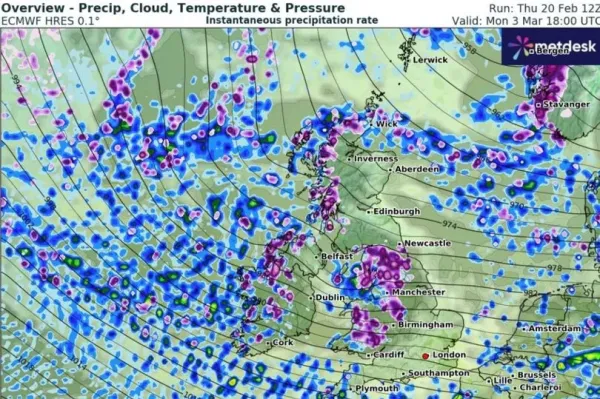
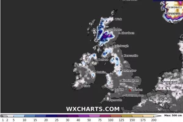
Maps using the ECMWF model show a band of wintry moving across the British Isles on March 3. A large swathe of northern including Yorkshire, Lancashire, and Cumbria are set to be covered by as much as 10cm of per hour, along with parts of and western . Some areas of and the East Midlands will also see snow showers, and heavy rain is meanwhile forecast in the southwest. By the following morning, accumulations of 12cm (4.7in) could be seen on the ground across the Pennines, rising to 27cm (11in) in the Highlands.
READ MORE:
It would mark a frosty turn after parts of the country experienced unseasonably mild weather in recent days. On Friday, a high of 17C was recorded in Hull's East Park - well above the seasonal average over 7-9C.
One forecaster has said the return to cold weather will begin around the end of the month. James Madden from Exacta Weather said: "We could see things turning more unsettled and gradually cooler once again, and in and around February 28th is likely to see a swift reversion back to quite cold conditions for many and an unusually late wintry blast, which will also bring a heightened snow risk of 2-5 days at the very least for some large parts of the UK and Ireland.
"However, our forecasts also expect and have maintained that the cold and wintry and/or wintry blast episodes would persist deep into spring in among some mild or very mild weather periods this year. The next wintry blast potential after the current cool-cold and wintry weather moderates from later next week could come around month-end and for in and around February 28, prior to further expected and very late wintry blasts in March and April."
In the meantime, yellow weather warnings have been issued for rain and wind this weekend covering large parts of northern England, Scotland, and Wales. An alert from the for this Sunday said the heavy rain "will accompany strong winds" and make for "very poor weather conditions, especially on roads". Winds will then ease in the warning area through the afternoon and early evening, beginning in areas furthest to the southeast.